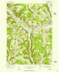
1954 Map of Van Etten
USGS Topo · Published 1956About this map
The Lehigh Valley railroad cuts a decisive path through this mid-century landscape, following the low-lying terrain of Cayuta Creek as it passes through the villages of Van Etten and Spencer. This 1954 field check captures the area’s post-war rural character, where small clusters of settlement like Swartwood and Rodbourn are linked by a network of winding roads named for the families who settled the surrounding uplands.
Find a feature on this map
48 named features on this map. Tap any name to fly to it.
Don’t see what you’re looking for? This feature index may not catch every label — zoom into the map to look around manually.
Map Details
Editions of this 1954 Van Etten Map
This is the sole edition of this map. No revisions or reprints were ever made.
Other maps of this area

1893 · Ithaca
USGS Topo · 1:62,500

1895 · Ithaca
USGS Topo · 1:62,500

1900 · Dryden
USGS Topo · 1:62,500

1902 · Waverly
USGS Topo · 1:62,500

1903 · Owego
USGS Topo · 1:62,500

1905 · Watkins Glen
USGS Topo · 1:125,000

1906 · Catatonk
USGS Topo · 1:125,000

1949 · Willseyville
USGS Topo · 1:24,000

1950 · Elmira
USGS Topo · 1:250,000

1950 · Alpine
USGS Topo · 1:24,000