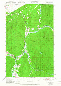
1951 Map of Van Zandt
USGS Topo · Published 1965About this map
The Nooksack River valley and its surrounding peaks define this portion of Whatcom County, where the Chicago Milwaukee St Paul and Pacific railroad traces a north-south path through the Columbia Valley. The map details a landscape of timber and extraction, evidenced by the Limestone Quarry near Limestone Junction and the heavy presence of mountain ranges like Sumas Mountain and Slide Mountain. Small communities and agricultural hubs such as Van Zandt, Clipper, and Maple Falls are connected by the Pacific Highway, illustrating the region's mid-century development. Notable local landmarks like the Welcome Grange and the Kendall Fish Hatchery appear alongside family-named sites such as Heislers Ranch and Jacobs Spur, providing specific points of interest for genealogists and local historians studying the rural character of the area.
Find a feature on this map
63 named features on this map. Tap any name to fly to it.
Don’t see what you’re looking for? This feature index may not catch every label — zoom into the map to look around manually.
Map Details
Editions of this 1951 Van Zandt Map
2 editions found
Other maps of this area

1906 · Sumas
USGS Topo · 1:62,500

1908 · Sumas
USGS Topo · 1:62,500

1909 · Mt Baker
USGS Topo · 1:192,000

1915 · Mt. Baker
USGS Topo · 1:250,000

1918 · Samish Lake
USGS Topo · 1:62,500

1919 · Van Zandt
USGS Topo · 1:62,500

1921 · Wickersham
USGS Topo · 1:62,500

1951 · Wickersham
USGS Topo · 1:62,500

1951 · Van Zandt
USGS Topo · 1:62,500

1952 · Lake Whatcom
USGS Topo · 1:24,000