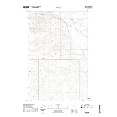
2020 Map of Vandalia
USGS Topo · Published 2020About this map
Vandalia sits at the heart of this Valley County landscape, positioned where the high plains of northern Montana meet the intricate drainage system of the Milk River. The map reveals a highly developed irrigation network essential to regional agriculture, most notably the Vandalia South Canal which snakes along the river's southern bank. This human-engineered waterway contrasts sharply with the natural erosion patterns of the surrounding breaks, defined by a series of deep coulees including Ash Coulee, Buffalo Coulee, and Long Coulee that drain toward the valley floor.
Find a feature on this map
18 named features on this map. Tap any name to fly to it.
Don’t see what you’re looking for? This feature index may not catch every label — zoom into the map to look around manually.
Map Details
Editions of this 2020 Vandalia Map
This is the sole edition of this map. No revisions or reprints were ever made.
Other maps of this area

1906 · Hinsdale Special Map
USGS Topo · 1:62,500

1943 · Glasgow
USGS Topo · 1:125,000

1954 · Glasgow
USGS Topo · 1:250,000

1957 · Glasgow
USGS Topo · 1:250,000

1958 · Glasgow
USGS Topo · 1:250,000

1958 · Engstrom Ranch
USGS Topo · 1:24,000

1958 · Miller Coulee
USGS Topo · 1:62,500
1958 · Billick Coulee
USGS Topo · 1:24,000
1969 · Tampico
USGS Topo · 1:24,000

1969 · Vandalia
USGS Topo · 1:24,000