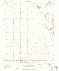
1956 Map of Vanguard
USGS Topo · Published 1957About this map
The agricultural heart of the San Joaquin Valley is defined by a grid of farm-to-market roads and the hydraulic engineering of the Kings River. In the mid-1950s, the landscape around the Fresno Co Kings Co line shows a transition from sprawling ranch lands like Barlow Ranch and Polder Ranch toward more industrial farm operations. A dedicated Labor Camp and a Cotton Gin at the settlement of Vanguard reflect the intensive labor and processing demands of the regional economy.
Find a feature on this map
34 named features on this map. Tap any name to fly to it.
Don’t see what you’re looking for? This feature index may not catch every label — zoom into the map to look around manually.
Map Details
Editions of this 1956 Vanguard Map
3 editions found
Other maps of this area

1912 · Coalinga
USGS Topo · 1:125,000

1924 · Riverdale
USGS Topo · 1:31,680

1926 · Lethent
USGS Topo · 1:31,680

1927 · Burrel
USGS Topo · 1:31,680

1927 · Riverdale
USGS Topo · 1:31,680

1927 · Lemoore
USGS Topo · 1:31,680

1929 · Stratford
USGS Topo · 1:31,680

1929 · Westhaven
USGS Topo · 1:31,680

1931 · Wheatville
USGS Topo · 1:31,680

1932 · West of Lethent
USGS Topo · 1:31,680