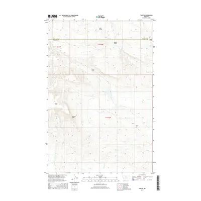
2017 Map of Vanstel
USGS Topo · Published 2017About this map
Vanstel and its surrounding ranchlands sit at the boundary of Garfield and Rosebud counties, defined by a landscape of deep coulees and seasonal watercourses. The local topography is marked by named drainage features like Lehner Coulee and Leach Coulee, which cut through the high plains toward Little Porcupine Cr. Genealogists and local researchers will find the Vanstel Cem south of the primary settlement area, a key site for documenting the families who settled this stretch of central Montana. Landmarks such as Blacktail Butte and Acorn Flats provide significant orientation points in a territory where the natural spring at Halvorson Hot Spring represents a notable hydrological feature amidst the ephemeral flows of Coyote Cr and Blacktail Cr.
Find a feature on this map
18 named features on this map. Tap any name to fly to it.
Don’t see what you’re looking for? This feature index may not catch every label — zoom into the map to look around manually.
Map Details
Editions of this 2017 Vanstel Map
This is the sole edition of this map. No revisions or reprints were ever made.
Other maps of this area

1954 · Forsyth
USGS Topo · 1:250,000

1957 · Forsyth
USGS Topo · 1:250,000

1958 · Forsyth
USGS Topo · 1:250,000

1960 · Brown Coulee
USGS Topo · 1:24,000

1965 · Acorn Flats
USGS Topo · 1:24,000

1965 · Kramer Ranch
USGS Topo · 1:24,000
1965 · Mother Butte
USGS Topo · 1:24,000
1965 · Antelope Springs
USGS Topo · 1:24,000

1965 · Vanstel
USGS Topo · 1:24,000

1965 · Stellar Lake
USGS Topo · 1:24,000