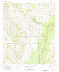
1964 Map of Vaughan
USGS Topo · Published 1983About this map
The Big Black River meanders across the eastern edge of this landscape, forming the natural boundary between Yazoo and Madison counties. This mid-century survey captures a rural Mississippi terrain defined by family-named landmarks and the critical transport corridor of the Illinois Central railroad. The small community of Vaughan sits along the rail line, serving as a focal point for the surrounding agricultural area, while Deasonville anchors the western portion of the sheet. Numerous country churches and family burial grounds are dispersed throughout the hills and creek bottoms, including Madvernize Ch, Bethel Ch, and Pepper Cem. The presence of several Oil Wells and a Radio Tower (KKA) reflects the modest industrial and communication footprint integrated into this predominantly agrarian environment of the 1960s.
Find a feature on this map
31 named features on this map. Tap any name to fly to it.
Don’t see what you’re looking for? This feature index may not catch every label — zoom into the map to look around manually.
Map Details
Editions of this 1964 Vaughan Map
3 editions found

Other maps of this area

1953 · Meridian
USGS Topo · 1:250,000

1955 · Jackson
USGS Topo · 1:250,000

1957 · Meridian
USGS Topo · 1:250,000

1960 · Sharon
USGS Topo · 1:62,500

1961 · Jackson
USGS Topo · 1:250,000

1961 · Canton
USGS Topo · 1:62,500

1962 · Jackson
USGS Topo · 1:250,000
1964 · Zeiglerville
USGS Topo · 1:24,000
1964 · Ebenezer
USGS Topo · 1:24,000

1964 · Linwood
USGS Topo · 1:24,000