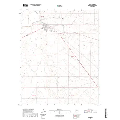
2023 Map of Vaughn
USGS Topo · Published 2023About this map
Vaughn serves as a critical transportation hub in the high plains of Guadalupe County, where major highways converge near the intersection of various municipal and township boundaries. The town's grid is well-defined by residential and commercial streets, including Hemstreet Ave and Cedar Ave, reflecting its role as a key stop for travelers and logistics in east-central New Mexico. Beyond the central hub, the landscape transitions into the open terrain of Long Draw, punctuated by rural infrastructure like Treasure Rd and Horace Rd. The presence of the Vaughn Municipal Airport and the Vaughn Evergreen Cem on the outskirts of the settlement highlights the essential community services that anchor this crossroads town. The surrounding rangelands, marked by the sparse settlement of Tony, emphasize the isolation and scale of the region's geography during the early twenty-first century.
Find a feature on this map
33 named features on this map. Tap any name to fly to it.
Don’t see what you’re looking for? This feature index may not catch every label — zoom into the map to look around manually.
Map Details
Editions of this 2023 Vaughn Map
This is the sole edition of this map. No revisions or reprints were ever made.
Other maps of this area

1954 · Fort Sumner
USGS Topo · 1:250,000

1958 · Fort Sumner
USGS Topo · 1:250,000

1978 · Mesa Leon
USGS Topo · 1:24,000

1978 · Santa Barbara Lake
USGS Topo · 1:24,000

1978 · Vaughn
USGS Topo · 1:24,000

1978 · Tejon
USGS Topo · 1:24,000

1978 · Long Draw
USGS Topo · 1:24,000
1978 · Burro Lake
USGS Topo · 1:24,000

1980 · Corona
USGS Topo · 1:100,000

1981 · Gacho Hill NW
USGS Topo · 1:24,000