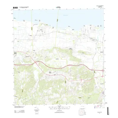
2013 Map of Vega Alta
USGS Topo · Published 2013About this map
The industrial legacy of northern Puerto Rico's sugar industry is anchored by Central San Vicente and Central Constancia, two prominent landmarks situated along the fertile coastal plains. This 2013 survey documents the landscape surrounding the municipalities of Vega Alta and Dorado, where the terrain transitions from the jagged limestone of the Cerros de Higuillar to the sandy shores of the Atlantic Ocean. The map traces a dense network of modern transportation including PR-2 and PR-693, which connect historic coastal settlements like Breñas and Sabana to the expanding interior neighborhoods of Monserrate and Ceiba. Coastal geography is detailed through prominent features such as Ensenada Breñas, Punta Mameyes, and Laguna Mata Redonda, providing a clear view of the shoreline before the further development of the Dorado area's northern beaches.
Find a feature on this map
58 named features on this map. Tap any name to fly to it.
Don’t see what you’re looking for? This feature index may not catch every label — zoom into the map to look around manually.
Map Details
Editions of this 2013 Vega Alta Map
This is the sole edition of this map. No revisions or reprints were ever made.
Other maps of this area

1940 · Vega Alta
USGS Topo · 1:30,000

1941 · Bayamon
USGS Topo · 1:30,000

1942 · Manati
USGS Topo · 1:30,000

1946 · Corozal
USGS Topo · 1:30,000

1946 · Ciales
USGS Topo · 1:30,000

1946 · Vega Alta
USGS Topo · 1:30,000

1946 · Naranjito
USGS Topo · 1:30,000

1946 · Manati
USGS Topo · 1:30,000

1947 · Corozal NO
USGS Topo · 1:10,000
1947 · Corozal NE
USGS Topo · 1:10,000