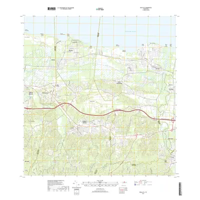
2018 Map of Vega Alta
USGS Topo · Published 2018About this map
Vega Alta and Dorado serve as central hubs in this coastal landscape, where the northern plains of Puerto Rico meet the Atlantic Ocean. The region’s connectivity is defined by the heavy artery of Expreso Jose de Diego, which cuts through a terrain marked by traditional settlements and modern expansion. Along the shoreline, the geography is punctuated by distinct points like Punta Cerro Gordo and Punta Mameyes, with recreational stretches at Playa de los Tocones and Playa de Sardinera. Local history is anchored by essential community landmarks, including the Cementerio Nuestra Señora del Carmen and the Cementerio Viejo Toa Alta. The hydrology of the area is dominated by the winding paths of the Río de la Plata and Río Cibuco, which irrigate the low-lying basins between the coastal limestone hills of the Cerros de Higuillar.
Find a feature on this map
47 named features on this map. Tap any name to fly to it.
Don’t see what you’re looking for? This feature index may not catch every label — zoom into the map to look around manually.
Map Details
Editions of this 2018 Vega Alta Map
This is the sole edition of this map. No revisions or reprints were ever made.
Other maps of this area

1940 · Vega Alta
USGS Topo · 1:30,000

1941 · Bayamon
USGS Topo · 1:30,000

1942 · Manati
USGS Topo · 1:30,000

1946 · Corozal
USGS Topo · 1:30,000

1946 · Ciales
USGS Topo · 1:30,000

1946 · Vega Alta
USGS Topo · 1:30,000

1946 · Naranjito
USGS Topo · 1:30,000

1946 · Manati
USGS Topo · 1:30,000

1947 · Corozal NO
USGS Topo · 1:10,000
1947 · Corozal NE
USGS Topo · 1:10,000