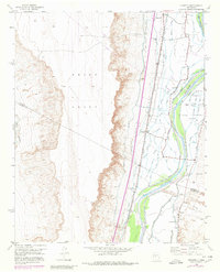
1952 Map of Veguita
USGS Topo · Published 1980About this map
Rio Grande waters dominate this mid-century landscape, fueling a complex network of irrigation that defines the agricultural life of the Middle Rio Grande Valley. The geography is structured by historic land grants, including the Belen Grant, Tome Grant, and Casa Colorada Grant, reflecting the region's deep colonial heritage. Numerous ditches and canals, such as the Bosque Ditch and Colorada Canal, branch from the river to support settlements like Jarales, Bosque, and Veguita.
Find a feature on this map
42 named features on this map. Tap any name to fly to it.
Don’t see what you’re looking for? This feature index may not catch every label — zoom into the map to look around manually.
Map Details
Editions of this 1952 Veguita Map
3 editions found
Other maps of this area

1916 · La Joya
USGS Topo · 1:125,000

1952 · La Joya NW
USGS Topo · 1:24,000

1952 · Belen SW
USGS Topo · 1:24,000

1952 · Black Butte
USGS Topo · 1:24,000

1952 · Belen
USGS Topo · 1:24,000

1952 · Turn
USGS Topo · 1:24,000

1952 · Veguita
USGS Topo · 1:24,000

1952 · Belen NW
USGS Topo · 1:24,000

1952 · Tome
USGS Topo · 1:24,000

1952 · Abeytas
USGS Topo · 1:24,000