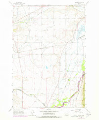
1963 Map of Vendome
USGS Topo · Published 1978About this map
Agricultural irrigation and heavy rail infrastructure define this portion of Jefferson County during the early 1960s. The landscape is marked by an extensive network of water management features, including the Delmoe Ditch, Jefferson Canal, and Pleasant Valley Ditch, which redirect flow from the Jefferson River to support the surrounding valley. This water system sits alongside the critical transport corridor of the Chicago Milwaukee St Paul and Pacific railroad, which services the small settlements of Vendome and Piedmont.
Find a feature on this map
28 named features on this map. Tap any name to fly to it.
Don’t see what you’re looking for? This feature index may not catch every label — zoom into the map to look around manually.
Map Details
Editions of this 1963 Vendome Map
2 editions found

Other maps of this area

1893 · Dillon
USGS Topo · 1:250,000

1955 · Dillon
USGS Topo · 1:250,000

1957 · Dillon
USGS Topo · 1:250,000

1958 · Dillon
USGS Topo · 1:250,000

1960 · Twin Bridges
USGS Topo · 1:62,500

1960 · Waterloo
USGS Topo · 1:62,500

1962 · Dillon
USGS Topo · 1:250,000
1963 · Dry Mountain
USGS Topo · 1:24,000
1963 · Whitehall
USGS Topo · 1:24,000
1963 · Black Butte
USGS Topo · 1:24,000