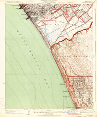
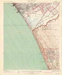
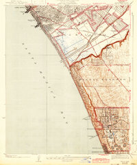
1934 Map of Venice
USGS Topo · Published 1934About this map
The coastal marshlands of La Ballona and the Ballona Lagoon dominate this coastal landscape, showing the area before the extensive modern marina developments. The map illustrates a complex network of transportation and industry, with the Pacific Electric lines connecting the seaside resorts of Venice and Playa del Rey to the industrial south. To the south, the massive Standard Oil Co Refinery at El Segundo stands as a significant industrial landmark, complete with its own dedicated Standard Oil Co Pier. The transition from the dense urban grid of Venice High Sch and the Venice Pier to the open, marshy terrain around Machado and Alla captures the coastal expansion of the era. The hills of Sausal Redondo rise above the shoreline, providing the foundation for Loyola University and early residential growth near Manhattan Beach.
Find a feature on this map
38 named features on this map. Tap any name to fly to it.
Don’t see what you’re looking for? This feature index may not catch every label — zoom into the map to look around manually.
Map Details
Editions of this 1934 Venice Map
3 editions found
Other maps of this area

1894 · Los Angeles
USGS Topo · 1:62,500

1896 · Redondo
USGS Topo · 1:62,500

1896 · Santa Monica
USGS Topo · 1:62,500

1898 · Santa Monica
USGS Topo · 1:62,500

1900 · Los Angeles
USGS Topo · 1:62,500

1901 · Southern California Sheet No. 1
USGS Topo · 1:250,000

1902 · Santa Monica
USGS Topo · 1:62,500

1903 · Calabasas
USGS Topo · 1:62,500

1903 · Camulos
USGS Topo · 1:125,000

1904 · Southern California Sheet No. 1
USGS Topo · 1:250,000