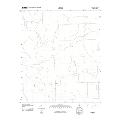
2010 Map of Verbena
USGS Topo · Published 2010About this map
Verbena sits as a quiet junction in Garza County, where the plains are etched by the winding course of the Salt Fork Brazos River. This landscape is defined by its drainage patterns, with Hensley Draw and Slicknasty Creek cutting through the terrain. In the northwest corner, water management is evident at Cash Lake, held by the Cash Lake Dam near the headwaters of Lake Creek. The area’s infrastructure is anchored by a grid of rural roads, including Kerr McGee Rd and FM 2008, which facilitate movement between the scattered water sources and local landmarks. The presence of named drainages like Bull Creek and McDonald Creek highlights the importance of seasonal water flow in this West Texas environment during the early 21st century.
Find a feature on this map
14 named features on this map. Tap any name to fly to it.
Don’t see what you’re looking for? This feature index may not catch every label — zoom into the map to look around manually.
Map Details
Editions of this 2010 Verbena Map
This is the sole edition of this map. No revisions or reprints were ever made.
Other maps of this area

1954 · Lubbock
USGS Topo · 1:250,000

1962 · Twomile Creek
USGS Topo · 1:24,000

1962 · Smith Tank
USGS Topo · 1:24,000

1966 · Kalgary
USGS Topo · 1:24,000

1966 · Canyon Valley
USGS Topo · 1:24,000

1969 · Verbena
USGS Topo · 1:24,000

1969 · Cap Rock SE
USGS Topo · 1:24,000

1969 · Cottonwood Creek
USGS Topo · 1:24,000
1969 · Justiceburg NW
USGS Topo · 1:24,000

1969 · Post East
USGS Topo · 1:24,000