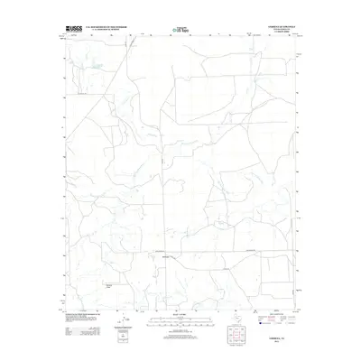
2012 Map of Verbena
USGS Topo · Published 2012About this map
Verbena serves as the focal point for this section of Garza County, situated within a landscape carved by the intricate drainage of the Salt Fork Brazos River. The terrain is defined by numerous seasonal and perennial waterways, including the winding McDonald Cr and the aptly named Slicknasty Cr, which navigate the elevation changes near Hensley Draw. This 2012 survey illustrates a rural environment primarily organized around ranching and energy infrastructure, as evidenced by the network of local routes like Kerr McGee RD and Ranch Road 651. Small water features like Cash Lake and Lake Cr provide localized water sources in an otherwise dry Texas landscape, while the branching paths of Bull Cr demonstrate the natural erosion patterns typical of the region's geography.
Find a feature on this map
15 named features on this map. Tap any name to fly to it.
Don’t see what you’re looking for? This feature index may not catch every label — zoom into the map to look around manually.
Map Details
Editions of this 2012 Verbena Map
This is the sole edition of this map. No revisions or reprints were ever made.
Other maps of this area

1954 · Lubbock
USGS Topo · 1:250,000

1962 · Twomile Creek
USGS Topo · 1:24,000

1962 · Smith Tank
USGS Topo · 1:24,000

1966 · Kalgary
USGS Topo · 1:24,000

1966 · Canyon Valley
USGS Topo · 1:24,000

1969 · Verbena
USGS Topo · 1:24,000

1969 · Cap Rock SE
USGS Topo · 1:24,000

1969 · Cottonwood Creek
USGS Topo · 1:24,000
1969 · Justiceburg NW
USGS Topo · 1:24,000

1969 · Post East
USGS Topo · 1:24,000