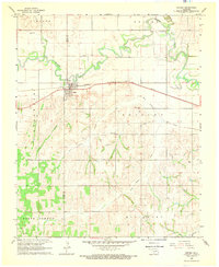
1968 Map of Verden
USGS Topo · Published 1969About this map
Verden serves as the central hub of this 1968 landscape, situated where the Chicago Rock Island and Pacific railroad crosses the meandering Washita River. The survey illustrates a rural economy balanced between agriculture and early industrial activity, noted by the presence of Sandpits and an Oil Well in the southern reaches. The community's social fabric is anchored by landmarks such as the Mennonite Ch and Elderberry Ch, alongside a small Cem near the river's northern bends. The terrain is defined by a network of drainage systems including Spring Creek, Rock Hollow Creek, and Tony Hollow Creek, which carve through the land south of the river. A Gaging Station and Sewage Disposal facility near the town site reflect the mid-century infrastructure supporting this Grady County settlement during a period of steady growth.
Find a feature on this map
23 named features on this map. Tap any name to fly to it.
Don’t see what you’re looking for? This feature index may not catch every label — zoom into the map to look around manually.
Map Details
Editions of this 1968 Verden Map
This is the sole edition of this map. No revisions or reprints were ever made.
Other maps of this area

1902 · Rush Springs
USGS Topo · 1:125,000

1904 · Chickasha
USGS Topo · 1:125,000

1945 · Anadarko
USGS Topo · 1:62,500

1949 · Cement
USGS Topo · 1:62,500

1949 · Rush Springs
USGS Topo · 1:62,500

1950 · Rush Springs
USGS Topo · 1:62,500

1954 · Oklahoma City
USGS Topo · 1:250,000

1955 · Lawton
USGS Topo · 1:250,000

1955 · Clinton
USGS Topo · 1:250,000

1956 · Laverty
USGS Topo · 1:24,000