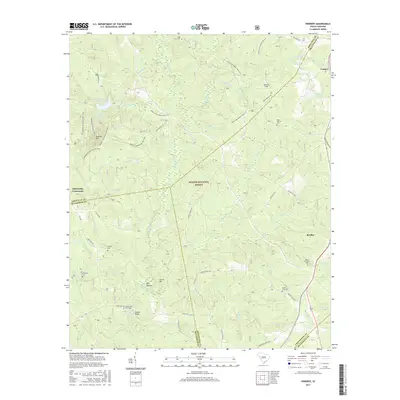
2017 Map of Verdery
USGS Topo · Published 2017About this map
Sumter National Forest dominates this landscape across the intersection of Greenwood, Abbeville, and McCormick counties, preserving a complex network of equestrian and off-highway vehicle trails. Named paths like the Long Cane Horse Trail S LP and Parson's Mountain OHV Trail loop through the wooded hills near Parsons Mtn. For genealogists and local historians, the sheet is exceptionally detailed with family-named burial sites, including the Lyon-Lipford Cem, Chisholm Cem, and Mount Sinai Cem. Small settlements and landmarks such as Bradley, Verdery, and Clatworthy Crossroads dot the perimeter of the federal lands, while the interior is defined by numerous watercourses like Long Cane Creek and Little Persimmon Br. This modern survey illustrates the enduring balance between managed timberlands, recreational trail systems, and the historic rural communities that border the forest boundary.
Find a feature on this map
64 named features on this map. Tap any name to fly to it.
Don’t see what you’re looking for? This feature index may not catch every label — zoom into the map to look around manually.
Map Details
Editions of this 2017 Verdery Map
This is the sole edition of this map. No revisions or reprints were ever made.
Other maps of this area

1892 · Mc Cormick
USGS Topo · 1:125,000

1892 · Abbeville
USGS Topo · 1:125,000

1912 · Mc Cormick
USGS Topo · 1:125,000

1948 · Abbeville East
USGS Topo · 1:24,000

1948 · Verdery
USGS Topo · 1:24,000

1948 · Abbeville West
USGS Topo · 1:24,000

1949 · Abbeville
USGS Topo · 1:24,000

1949 · Calhoun Creek
USGS Topo · 1:24,000

1949 · Greenwood
USGS Topo · 1:24,000

1950 · Bradley
USGS Topo · 1:24,000
Featured Places
- Bradley Corner, SC
- Clatworthy Crossroads, SC
- Cedar Springs, SC
- Abbeville County, SC
- Greenwood County, SC