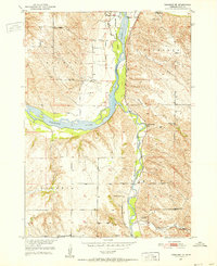
1950 Map of Verdigre NE
USGS Topo · Published 1952About this map
The Niobrara River carves through the landscape of Knox County in the early 1950s, meeting the winding course of Verdigre Creek amidst the upland plateaus of Raymond and Bohemia. This era preserves a rural infrastructure defined by numerous country schools, including Pleasant Hill Sch and School No 51, which served the farming families across the region. The Chicago and North Western railroad tracks follow the river valleys, providing a vital link to the settlement of Niobrara and the nearby Ponca. Cultural landmarks such as St Johns Cem and the White Mountain Lodge Cem offer tangible points of interest for genealogists tracing local family histories. The presence of Niobrara State Park along the river bluffs illustrates the early development of recreational land use in this corner of Nebraska.
Find a feature on this map
24 named features on this map. Tap any name to fly to it.
Don’t see what you’re looking for? This feature index may not catch every label — zoom into the map to look around manually.
Map Details
Editions of this 1950 Verdigre NE Map
3 editions found
Other maps of this area

1950 · Niobrara
USGS Topo · 1:24,000

1950 · Verdel
USGS Topo · 1:24,000

1950 · Verdigre NE
USGS Topo · 1:24,000

1950 · Pishelville
USGS Topo · 1:24,000

1954 · Walnut
USGS Topo · 1:24,000

1954 · Verdigre
USGS Topo · 1:24,000

1955 · Sioux City
USGS Topo · 1:250,000

1955 · O'Neill
USGS Topo · 1:250,000

1958 · Sioux City
USGS Topo · 1:250,000

1959 · O'Neill
USGS Topo · 1:250,000