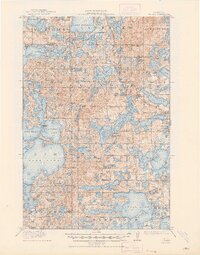
1915 Map of Vergas
USGS Topo · Published 1948About this map
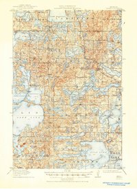
Glacial lakes and rural schoolhouses define this 1912 survey of the Vergas area, captured just as the Northern Pacific (Winnipeg Line) railroad influenced local commerce and travel. The landscape is a dense network of water bodies, including the expansive Lake Lida, Pelican Lake, and Lake Lizzie, which supported early recreation and industry. Travelers found rest at the Pelican Inn or Websters Inn, while the agricultural community was anchored by a high density of rural school districts, such as Jacobs School, School No 80, and School No 254. The presence of Mill Pond and the Pelican River suggests the early hydraulic processing that once drove local economies. This survey reflects the region before the consolidation of many small school districts, preserving the exact locations of dozens of one-room schoolhouses that once dotted the townships of Dora, Candor, and Lida.
Find a feature on this map
91 named features on this map. Tap any name to fly to it.
Don’t see what you’re looking for? This feature index may not catch every label — zoom into the map to look around manually.
Map Details
Editions of this 1915 Vergas Map
6 editions found
Other maps of this area

1912 · Vergas
USGS Topo · 1:62,500

1912 · Battle Lake
USGS Topo · 1:62,500

1913 · Fergus Falls
USGS Topo · 1:62,500

1914 · Battle Lake
USGS Topo · 1:62,500

1914 · Pelican Rapids
USGS Topo · 1:62,500

1915 · Underwood
USGS Topo · 1:62,500

1915 · Perham
USGS Topo · 1:62,500

1915 · Vergas
USGS Topo · 1:62,500

1917 · Pelican Rapids
USGS Topo · 1:62,500

1953 · Fargo
USGS Topo · 1:250,000
Featured Places
- Lake Eunice, MN
- Vergas, MN
- Bucks Mill, MN
- Heisler Manufactured Home Park, MN
- Mavis Frazier Trailer Park, MN