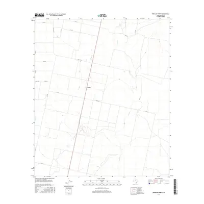
2016 Map of Verhalen North
USGS Topo · Published 2016About this map
Hoban serves as the central focal point of this arid West Texas landscape, situated along the north-south transit corridor of State Highway 17. The terrain is defined by the ephemeral drainage patterns of Cherry Cr to the west and Toyah Cr to the east, illustrating the typical hydrology of Reeves County where seasonal watercourses carve through the desert floor. The map documents a sparse but deliberate network of rural infrastructure, from the diagonal path of Ranch Rd 869 to numerous county routes such as Barrilla Rd and Co Rd 125 that partition the open range. This 2016 survey captures the area's transition into modern agricultural and industrial use, shown through the varied grid of land divisions and secondary roads like W C 113 that connect the remote reaches of the Trans-Pecos region.
Find a feature on this map
18 named features on this map. Tap any name to fly to it.
Don’t see what you’re looking for? This feature index may not catch every label — zoom into the map to look around manually.
Map Details
Editions of this 2016 Verhalen North Map
This is the sole edition of this map. No revisions or reprints were ever made.
Other maps of this area

1921 · Toyah
USGS Topo · 1:125,000

1931 · Barstow
USGS Topo · 1:125,000

1954 · Pecos
USGS Topo · 1:250,000

1955 · Saragosa
USGS Topo · 1:62,500

1957 · Pecos
USGS Topo · 1:250,000

1963 · Toyah Lake
USGS Topo · 1:24,000

1970 · Hermosa SW
USGS Topo · 1:24,000
1970 · Barstow 3 SW
USGS Topo · 1:24,000
1970 · Verhalen South
USGS Topo · 1:24,000
1970 · Saragosa NW
USGS Topo · 1:24,000