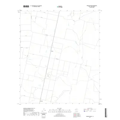
2019 Map of Verhalen North
USGS Topo · Published 2019About this map
Verhalen and Hoban anchor this high desert landscape in Reeves County, Texas, where an organized grid of county roads meets the natural drainage of the Trans-Pecos. The map illustrates a transitional zone where human settlement follows the arterial paths of Ranch Rd 869 and Barrilla Rd. Significant ephemeral watercourses, including Toyah Cr and Cherry Cr, carve winding paths across the otherwise linear surveying of the terrain. The proximity of these two small communities along the roadway network suggests a legacy of ranching and early agricultural development in this arid region. Researchers can trace the exact footprint of local infrastructure from Co Rd 112 to the northern reaches of Co Rd 128, revealing how the land was partitioned and accessed in the early 21st century.
Find a feature on this map
19 named features on this map. Tap any name to fly to it.
Don’t see what you’re looking for? This feature index may not catch every label — zoom into the map to look around manually.
Map Details
Editions of this 2019 Verhalen North Map
This is the sole edition of this map. No revisions or reprints were ever made.
Other maps of this area

1921 · Toyah
USGS Topo · 1:125,000

1931 · Barstow
USGS Topo · 1:125,000

1954 · Pecos
USGS Topo · 1:250,000

1955 · Saragosa
USGS Topo · 1:62,500

1957 · Pecos
USGS Topo · 1:250,000

1963 · Toyah Lake
USGS Topo · 1:24,000

1970 · Hermosa SW
USGS Topo · 1:24,000
1970 · Barstow 3 SW
USGS Topo · 1:24,000
1970 · Verhalen South
USGS Topo · 1:24,000
1970 · Saragosa NW
USGS Topo · 1:24,000