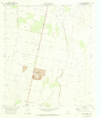
1971 Map of Verhalen North
USGS Topo · Published 1973About this map
Pecos Valley Southern railroad tracks run north-to-south through this arid stretch of Reeves County, serving a landscape defined by ranching, resource extraction, and early irrigation efforts. Small rail-stop settlements like Hoban, Collier, and Verhalen anchor the line, providing focal points for local history research in this West Texas territory. The terrain is marked by seasonal drainage patterns, most notably Toyah Creek and its tributary Cherry Creek, which cut through the level plains. Extensive Gravel Pits near Collier reveal the industrial utility of the land, while numerous wells and drill holes scattered across the survey indicate the persistent search for groundwater and minerals during the early 1970s. Fine red dashed lines throughout the map provide an unusually detailed look at fence lines and property divisions of the era.
Find a feature on this map
9 named features on this map. Tap any name to fly to it.
Don’t see what you’re looking for? This feature index may not catch every label — zoom into the map to look around manually.
Map Details
Editions of this 1971 Verhalen North Map
This is the sole edition of this map. No revisions or reprints were ever made.
Other maps of this area

1921 · Toyah
USGS Topo · 1:125,000

1931 · Barstow
USGS Topo · 1:125,000

1954 · Pecos
USGS Topo · 1:250,000

1955 · Saragosa
USGS Topo · 1:62,500

1957 · Pecos
USGS Topo · 1:250,000

1963 · Toyah Lake
USGS Topo · 1:24,000

1970 · Hermosa SW
USGS Topo · 1:24,000
1970 · Barstow 3 SW
USGS Topo · 1:24,000
1970 · Verhalen South
USGS Topo · 1:24,000
1970 · Saragosa NW
USGS Topo · 1:24,000