
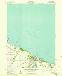
1959 Map of Vermilion West
USGS Topo · Published 1960About this map
The southern shoreline of Lake Erie defines the character of this late-1950s coastal landscape, where a dense network of lakeside communities and beach resorts stretches between Berlin and Vermilion. The map documents a transition from the industrial and transport corridors of the New York Central and St Louis Railroad and the Chicago and St Louis Railroad to the seasonal leisure areas of Ruggles Beach, Mitiwanga, and Beulah Beach. Inland, the terrain is segmented by family-named routes such as Joppa Road and Coen Road, which serve agricultural lands drained by several north-flowing waterways, including Cranberry Creek and Sugar Creek. The placement of infrastructure like the Sewage Disposal plant near the mouth of the river indicates the early modern development of the Vermilion township area.
Find a feature on this map
31 named features on this map. Tap any name to fly to it.
Don’t see what you’re looking for? This feature index may not catch every label — zoom into the map to look around manually.
Map Details
Editions of this 1959 Vermilion West Map
This is the sole edition of this map. No revisions or reprints were ever made.
Other maps of this area

1903 · Vermilion
USGS Topo · 1:62,500

1904 · Sandusky
USGS Topo · 1:62,500

1916 · Kelleys Island
USGS Topo · 1:62,500

1919 · Kelleys Island
USGS Topo · 1:62,500

1956 · Toledo
USGS Topo · 1:250,000

1959 · Milan
USGS Topo · 1:24,000

1959 · Berlin Heights
USGS Topo · 1:24,000

1959 · Vermilion East
USGS Topo · 1:24,000

1959 · Kipton
USGS Topo · 1:24,000
1959 · Huron
USGS Topo · 1:24,000