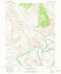
1964 Map of Vernal SE
USGS Topo · Published 1979About this map
The Green River carves a dramatic path through the southern portion of this landscape, forming the massive loop known as Horseshoe Bend and the distinctively oxbow-shaped The Stirrup. These riparian flats, including Hamacker Bottoms, provide a sharp contrast to the arid, high-altitude terrain dominated by Asphalt Ridge in the northeast. The geography here is defined by early energy exploration and livestock management, evidenced by the Uinta Basin Seismological Observatory and scattered ranching infrastructure like McCoy Flat Corral.
Find a feature on this map
21 named features on this map. Tap any name to fly to it.
Don’t see what you’re looking for? This feature index may not catch every label — zoom into the map to look around manually.
Map Details
Editions of this 1964 Vernal SE Map
2 editions found
Other maps of this area

1885 · Ashley
USGS Topo · 1:250,000

1907 · Jensen
USGS Topo · 1:125,000

1910 · Jensen
USGS Topo · 1:125,000

1917 · Vernal
USGS Topo · 1:125,000

1954 · Vernal
USGS Topo · 1:250,000

1958 · Vernal
USGS Topo · 1:250,000

1960 · Vernal
USGS Topo · 1:250,000

1964 · Vernal NE
USGS Topo · 1:24,000

1964 · Brennan Basin
USGS Topo · 1:24,000
1964 · Vernal SW
USGS Topo · 1:24,000