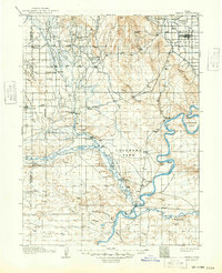
1917 Map of Vernal
USGS Topo · Published 1948About this map
The confluence of the Duchesne River and the Green River serves as the central focal point of this 1913-1914 survey of the Uinta Basin. At this critical junction lies Ouray, a hub for the surrounding livestock and agricultural landscapes. To the north, the Uinta River and Whiterocks River descend from the mountains, feeding a system of irrigation that includes the Uinta Canal and Ouray Valley Canal. These water systems supported early 20th-century settlements like Fort Duchesne, Randlett, and Moffat.
Find a feature on this map
76 named features on this map. Tap any name to fly to it.
Don’t see what you’re looking for? This feature index may not catch every label — zoom into the map to look around manually.
Map Details
Editions of this 1917 Vernal Map
2 editions found

Other maps of this area

1885 · East Tavaputs
USGS Topo · 1:250,000

1885 · Ashley
USGS Topo · 1:250,000

1885 · Uinta
USGS Topo · 1:250,000

1886 · Price River
USGS Topo · 1:250,000

1896 · Price River
USGS Topo · 1:250,000

1905 · Gilbert Peak
USGS Topo · 1:125,000

1906 · Gilbert Peak
USGS Topo · 1:125,000

1906 · Marsh Peak
USGS Topo · 1:125,000

1907 · Jensen
USGS Topo · 1:125,000

1908 · Marsh Peak
USGS Topo · 1:125,000