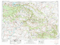
1954 Map of Vernal
USGS Topo · Published 1974About this map
The Green River carves a path through this mid-century look at the High Uintas and the Colorado Plateau, where the newly formed Flaming Gorge Reservoir dominates the northern border between Utah and Wyoming. The map documents a landscape defined by industrial and recreational transitions, from the petroleum-rich Asphalt Ridge near Vernal to the federal management of the Ashley National Forest and the Dinosaur National Monument. The settlement pattern follows the fertile valleys and river bends, with Roosevelt, Ouray, and Jensen serving as regional hubs.
Find a feature on this map
94 named features on this map. Tap any name to fly to it.
Don’t see what you’re looking for? This feature index may not catch every label — zoom into the map to look around manually.
Map Details
Editions of this 1954 Vernal Map
4 editions found

Other maps of this area

1885 · East Tavaputs
USGS Topo · 1:250,000

1885 · Ashley
USGS Topo · 1:250,000

1885 · Uinta
USGS Topo · 1:250,000

1886 · Price River
USGS Topo · 1:250,000

1896 · Price River
USGS Topo · 1:250,000

1905 · Gilbert Peak
USGS Topo · 1:125,000

1906 · Gilbert Peak
USGS Topo · 1:125,000

1906 · Marsh Peak
USGS Topo · 1:125,000

1906 · Grand Hogback
USGS Topo · 1:125,000

1907 · Rangely
USGS Topo · 1:125,000