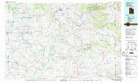
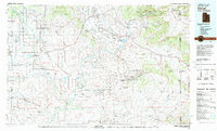
1980 Map of Vernal
USGS Topo · Published 1982About this map
Vernal and the surrounding Ashley Valley serve as the hub of this eastern Utah landscape, where the agricultural traditions of the valley meet a burgeoning energy sector. By the early 1980s, the region was defined by a complex network of resource extraction, evidenced by the extensive Red Wash Oil and Gas Field and the Wonsits-Wonsits Valley Oil Field. The confluence of the Duchesne River and the Green River near Ouray highlights the critical importance of water in this high desert, supporting both local irrigation and the protected wetlands of the Ouray National Wildlife Refuge. In the northeast, the dramatic uplift of Split Mountain and the Yampa Plateau within Dinosaur National Monument provides a stark contrast to the flatter industrial expanses of Deadman Bench and Leland Bench. This map documents a transitional period for settlements like Fort Duchesne and Bonanza as they balanced federal land management, indigenous heritage, and the industrial demands of the Uinta Basin.
Find a feature on this map
55 named features on this map. Tap any name to fly to it.
Don’t see what you’re looking for? This feature index may not catch every label — zoom into the map to look around manually.
Map Details
Editions of this 1980 Vernal Map
2 editions found
Other maps of this area

1885 · East Tavaputs
USGS Topo · 1:250,000

1885 · Ashley
USGS Topo · 1:250,000

1885 · Uinta
USGS Topo · 1:250,000

1886 · Price River
USGS Topo · 1:250,000

1896 · Price River
USGS Topo · 1:250,000

1905 · Gilbert Peak
USGS Topo · 1:125,000

1906 · Gilbert Peak
USGS Topo · 1:125,000

1906 · Marsh Peak
USGS Topo · 1:125,000

1907 · Rangely
USGS Topo · 1:125,000

1907 · Jensen
USGS Topo · 1:125,000