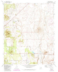
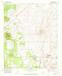
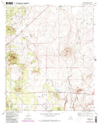
1971 Map of Vernon
USGS Topo · Published 1985About this map
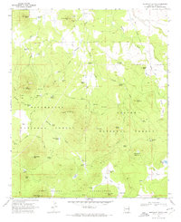
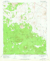
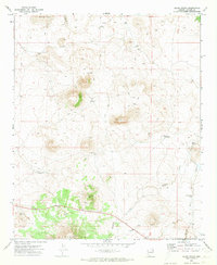
Vernon serves as the focal point of this high-altitude landscape, where the Sitgreaves Nat Forest meets a network of seasonal watercourses and volcanic landforms. Evidence of early cattle ranching and settlement is scattered across the terrain at locations like Floy (Site) near Laguna Salada and Bannon (Site) to the south. The mapping highlights a reliance on sparse water sources, such as Laguna Salada Spring and Little Ortega Lake, which provided critical relief in this arid region of Apache County. Geometric fence lines and the Mineral Creek Jeep Trail indicate a working landscape defined by grazing and resource extraction, specifically at the Cinder Pit near Dutch Mountain. The presence of several named knolls like Smooth Knoll and Burnt Knoll provides a clear view of the volcanic topography that dictates the drainage patterns of Mineral Creek and Sepulveda Creek.
Find a feature on this map
20 named features on this map. Tap any name to fly to it.
Don’t see what you’re looking for? This feature index may not catch every label — zoom into the map to look around manually.
Map Details
Editions of this 1971 Vernon Map
3 editions found
Other maps of this area

1886 · St Johns
USGS Topo · 1:250,000

1892 · St Johns
USGS Topo · 1:250,000

1954 · Saint Johns
USGS Topo · 1:250,000

1957 · Saint Johns
USGS Topo · 1:250,000

1958 · Saint Johns
USGS Topo · 1:250,000
1961 · McNary
USGS Topo · 1:62,500

1962 · Saint Johns
USGS Topo · 1:250,000
1968 · Boundary Butte
USGS Topo · 1:24,000
1969 · Whiting Knoll
USGS Topo · 1:24,000
1971 · Cerro Hueco
USGS Topo · 1:24,000