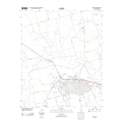
2012 Map of Vernon
USGS Topo · Published 2012About this map
The Pease River valley defines the landscape south of the city of Vernon, where the local drainage network includes Wildcat Cr, Boggy Cr, and Paradise Cr. This 2012 survey illustrates the layout of the regional seat and the surrounding agricultural grid, characterized by an extensive system of county roads such as Co Rd-114 W and Co Rd-118 E. The map documents the northern outskirts where the Wilbarger County Airport sits along the road to Oklahoma.
Find a feature on this map
104 named features on this map. Tap any name to fly to it.
Don’t see what you’re looking for? This feature index may not catch every label — zoom into the map to look around manually.
Map Details
Editions of this 2012 Vernon Map
This is the sole edition of this map. No revisions or reprints were ever made.
Other maps of this area

1955 · Lawton
USGS Topo · 1:250,000

1958 · Davidson
USGS Topo · 1:62,500

1958 · Frederick
USGS Topo · 1:62,500

1958 · Vernon
USGS Topo · 1:62,500

1958 · Elmer
USGS Topo · 1:62,500

1975 · Frederick SW
USGS Topo · 1:24,000
1983 · Boggy Creek
USGS Topo · 1:24,000

1983 · Tolbert
USGS Topo · 1:24,000
1983 · Rayland
USGS Topo · 1:24,000
1983 · Lockett
USGS Topo · 1:24,000