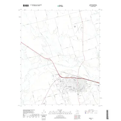
2019 Map of Vernon
USGS Topo · Published 2019About this map
Vernon serves as the focal point of this Wilbarger County survey, situated just south of the meandering Pease River. The town's grid is well-defined, reaching north toward Country Club Rd and Sullivan St, while the surrounding landscape is shaped by several drainages including Wildcat Cr and Paradise Cr. To the north, the Wilbarger County Airport stands as a significant regional landmark, connected to the city center by a network of county roads. The local hydrology is further punctuated by Condon Springs near the riverbanks. This 21st-century record captures the modern footprint of the settlement, showing the established residential streets like Maiden St and Pease St alongside the commercial and transportation infrastructure that supports the northern Texas plains.
Find a feature on this map
104 named features on this map. Tap any name to fly to it.
Don’t see what you’re looking for? This feature index may not catch every label — zoom into the map to look around manually.
Map Details
Editions of this 2019 Vernon Map
This is the sole edition of this map. No revisions or reprints were ever made.
Other maps of this area

1955 · Lawton
USGS Topo · 1:250,000

1958 · Davidson
USGS Topo · 1:62,500

1958 · Frederick
USGS Topo · 1:62,500

1958 · Vernon
USGS Topo · 1:62,500

1958 · Elmer
USGS Topo · 1:62,500

1975 · Frederick SW
USGS Topo · 1:24,000
1983 · Boggy Creek
USGS Topo · 1:24,000

1983 · Tolbert
USGS Topo · 1:24,000
1983 · Rayland
USGS Topo · 1:24,000
1983 · Lockett
USGS Topo · 1:24,000