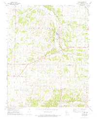
1972 Map of Verona
USGS Topo · Published 1973About this map
Verona serves as the primary hub of this early 1970s landscape, situated where the St Louis - San Francisco railroad follows the winding course of the Spring River. This corridor reflects the historical importance of rail and water in Lawrence County, connecting small communities like Globe and Pleasant Ridge. The map documents a predominantly agricultural region defined by drainage networks including Center Creek, Kelly Creek, and Prairie Run. Local heritage is anchored by landmarks such as New Liberty Ch, Spring River Cem, and Calton Cem, providing valuable points of reference for genealogists. The topography transitions toward the Ozark region to the southeast, with significant terrain features like Browning Hollow carving through the limestone-rich landscape. Cultural footprints range from a Roadside Park along the highway to the industrial presence of a Substation and Sewage Disposal Ponds near the main township.
Find a feature on this map
26 named features on this map. Tap any name to fly to it.
Don’t see what you’re looking for? This feature index may not catch every label — zoom into the map to look around manually.
Map Details
Editions of this 1972 Verona Map
This is the sole edition of this map. No revisions or reprints were ever made.
Other maps of this area

1886 · Greenfield
USGS Topo · 1:125,000

1888 · Greenfield
USGS Topo · 1:125,000

1919 · Halltown
USGS Topo · 1:62,500

1921 · Stotts City
USGS Topo · 1:62,500

1942 · Aurora
USGS Topo · 1:62,500

1943 · Monett
USGS Topo · 1:62,500

1945 · Harrison
USGS Topo · 1:250,000

1945 · Aurora
USGS Topo · 1:62,500

1949 · Harrison
USGS Topo · 1:250,000

1954 · Harrison
USGS Topo · 1:250,000