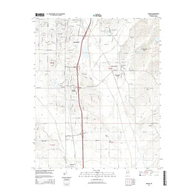
2015 Map of Verona
USGS Topo · Published 2015About this map
Tupelo and its southern suburbs anchor this Lee County landscape, where urban development meets the low-lying drainage basins of Town Creek and Coonewah Creek. The map documents a corridor of growth along Verona Heights and Verona, transitioning into the smaller rural crossroads of Plantersville, Brewer, and Union. This area is particularly detailed in its mapping of smaller family-named landmarks and historical burial grounds, including the English Family Cemetery and the Williams-Hill Family Cemetery. The presence of Old Union and the Old Chapel Cemetery suggests the long-standing community foundations that preceded the expansion of Lee Acres and modern residential tracts. Water features like Barley Lake and Longs Lake dot the terrain, which is defined by the complex network of creeks such as Kings Creek and Louisa Creek that flow toward the larger Town Creek system.
Find a feature on this map
63 named features on this map. Tap any name to fly to it.
Don’t see what you’re looking for? This feature index may not catch every label — zoom into the map to look around manually.
Map Details
Editions of this 2015 Verona Map
This is the sole edition of this map. No revisions or reprints were ever made.
Other maps of this area

1921 · Tupelo
USGS Topo · 1:48,000

1923 · Tupelo
USGS Topo · 1:62,500

1955 · Sherman
USGS Topo · 1:62,500

1956 · Tupelo
USGS Topo · 1:250,000

1958 · Tupelo
USGS Topo · 1:250,000

1965 · Mooreville
USGS Topo · 1:24,000

1966 · Shannon
USGS Topo · 1:24,000
1966 · Nettleton
USGS Topo · 1:24,000

1966 · Troy SE
USGS Topo · 1:24,000

1966 · Evergreen
USGS Topo · 1:24,000