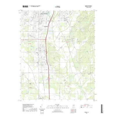
2018 Map of Verona
USGS Topo · Published 2018About this map
The Private John Allen National Fish Hatchery occupies a significant footprint in the northern portion of this Lee County landscape, situated just north of the growing city of Tupelo. The area is characterized by a mix of educational hubs, including the University of Mississippi Tupelo and Itawamba Community College, alongside established residential and industrial corridors. The Kansas City Southern railroad serves as a central spine through the region, connecting the primary settlements of Verona, Plantersville, and Shannon. South of these larger centers, the terrain transitions into more rural agricultural lands punctuated by small settlements like Brewer, Old Union, and Union. Genealogists will find a high density of small burial grounds throughout the countryside, ranging from the Williams-Hill Family Cem to the English Family Cem, preserving the heritage of local family landholdings.
Find a feature on this map
190 named features on this map. Tap any name to fly to it.
Don’t see what you’re looking for? This feature index may not catch every label — zoom into the map to look around manually.
Map Details
Editions of this 2018 Verona Map
This is the sole edition of this map. No revisions or reprints were ever made.
Other maps of this area

1921 · Tupelo
USGS Topo · 1:48,000

1923 · Tupelo
USGS Topo · 1:62,500

1955 · Sherman
USGS Topo · 1:62,500

1956 · Tupelo
USGS Topo · 1:250,000

1958 · Tupelo
USGS Topo · 1:250,000

1965 · Mooreville
USGS Topo · 1:24,000

1966 · Shannon
USGS Topo · 1:24,000
1966 · Nettleton
USGS Topo · 1:24,000

1966 · Troy SE
USGS Topo · 1:24,000

1966 · Evergreen
USGS Topo · 1:24,000