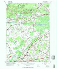
1955 Map of Verona
USGS Topo · Published 1967About this map
Verona and the surrounding Oneida County countryside appear here during a period of transition, where mid-century transportation infrastructure overlays the historic water and rail routes of Central New York. The northern landscape is defined by the Sand Plains and the prominent watercourse of Wood Creek, which runs parallel to the Erie Canal and the Old Erie Canal. This convergence of waterways near New London and Stacy Basin illustrates the long-standing importance of this corridor for regional commerce.
Find a feature on this map
49 named features on this map. Tap any name to fly to it.
Don’t see what you’re looking for? This feature index may not catch every label — zoom into the map to look around manually.
Map Details
Editions of this 1955 Verona Map
3 editions found
Other maps of this area

1895 · Oriskany
USGS Topo · 1:62,500

1895 · Oneida
USGS Topo · 1:62,500

1898 · Oneida
USGS Topo · 1:62,500

1898 · Oriskany
USGS Topo · 1:62,500

1902 · Oneida
USGS Topo · 1:62,500

1904 · Boonville
USGS Topo · 1:62,500

1905 · Taberg
USGS Topo · 1:62,500

1939 · Oneida
USGS Topo · 1:62,500

1943 · Camden East
USGS Topo · 1:31,680

1943 · Lee Center
USGS Topo · 1:31,680