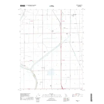
2018 Map of Verona
USGS Topo · Published 2018About this map
The Sacramento River and Feather River converge at the settlement of Verona, marking a landscape defined by industrial-scale water management within the Sacramento Valley. This 2018 survey reveals the intricate network of the American Basin, where the Cross Canal, Pleasant Grove Creek Canal, and Main Canal segment the fertile valley floor. The region’s agricultural aviation history is evidenced by several private airfields, including the Scheidel Ranch Airport, James Brothers Airport, and the Riego Flight Strip. Local landmarks such as Barney Mound and the Pleasant Grove Cem provide specific points of interest for those tracking family roots in Sutter County. The map details the transition from riparian corridors to the grid-patterned fields of the Central Valley, connected by local thoroughfares like El Centro Blvd and the Garden Hwy.
Find a feature on this map
54 named features on this map. Tap any name to fly to it.
Don’t see what you’re looking for? This feature index may not catch every label — zoom into the map to look around manually.
Map Details
Editions of this 2018 Verona Map
This is the sole edition of this map. No revisions or reprints were ever made.
Other maps of this area

1891 · Sacramento
USGS Topo · 1:125,000

1892 · Sacramento
USGS Topo · 1:125,000

1893 · Sacramento
USGS Topo · 1:125,000

1902 · Fairoaks
USGS Topo · 1:62,500

1907 · Davisville
USGS Topo · 1:62,500

1910 · Sheridan
USGS Topo · 1:31,680

1910 · Knights Landing
USGS Topo · 1:31,680

1910 · Vernon
USGS Topo · 1:31,680

1910 · Nicolaus
USGS Topo · 1:31,680

1910 · Pleasant Grove
USGS Topo · 1:31,680