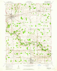
1961 Map of Versailles
USGS Topo · Published 1962About this map
Versailles and Bradford serve as the primary hubs in this western Ohio landscape, where the confluence of the New York Central and Pennsylvania railroads once dictated the flow of local commerce. The terrain is deeply tied to its watercourses, notably the meandering Stillwater River and its tributaries like Indian Creek and Harris Creek. This 1961 survey captures the rural character of the region, punctuated by numerous crossroads settlements such as Cassels Corners and Blind Corners.
Find a feature on this map
61 named features on this map. Tap any name to fly to it.
Don’t see what you’re looking for? This feature index may not catch every label — zoom into the map to look around manually.
Map Details
Editions of this 1961 Versailles Map
2 editions found
Other maps of this area

1908 · St. Henry
USGS Topo · 1:62,500

1909 · Loramie
USGS Topo · 1:62,500

1911 · Loramie
USGS Topo · 1:62,500

1911 · Covington
USGS Topo · 1:62,500

1944 · Covington
USGS Topo · 1:62,500

1944 · Loramie
USGS Topo · 1:62,500

1953 · Muncie
USGS Topo · 1:250,000

1956 · Muncie
USGS Topo · 1:250,000

1961 · Dawn
USGS Topo · 1:24,000
1961 · Piqua West
USGS Topo · 1:24,000