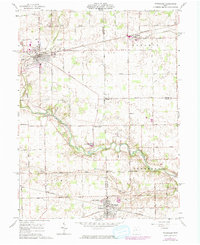
1961 Map of Versailles
USGS Topo · Published 1974About this map
The Stillwater River meanders through the heart of this landscape, forming a natural boundary that defines the intersection of Darke, Shelby, and Miami counties. The rail-oriented growth of Versailles and Bradford is evident, both settlements situated along the Penn Central line which bisects the agricultural plains. Smaller crossroads communities such as Russia, Webster, and Bloomer dot the surrounding countryside, each anchored by local landmarks like St Valberts Ch or St Peters Ch. Genealogists will find a wealth of burial sites preserved here, from the larger English Cem near Versailles to the smaller Old Harris Creek Cem and Miller Cem nestled near the southern banks of Harris Creek. The terrain is marked by the presence of Gravel Pits and various creek systems, including Swamp Creek and Ninemile Creek, which drain into the main river valley.
Find a feature on this map
68 named features on this map. Tap any name to fly to it.
Don’t see what you’re looking for? This feature index may not catch every label — zoom into the map to look around manually.
Map Details
Editions of this 1961 Versailles Map
2 editions found
Other maps of this area

1908 · St. Henry
USGS Topo · 1:62,500

1909 · Loramie
USGS Topo · 1:62,500

1911 · Loramie
USGS Topo · 1:62,500

1911 · Covington
USGS Topo · 1:62,500

1944 · Covington
USGS Topo · 1:62,500

1944 · Loramie
USGS Topo · 1:62,500

1953 · Muncie
USGS Topo · 1:250,000

1956 · Muncie
USGS Topo · 1:250,000

1961 · Dawn
USGS Topo · 1:24,000
1961 · Piqua West
USGS Topo · 1:24,000