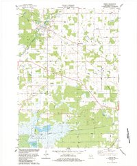
1984 Map of Vesper
USGS Topo · Published 1984About this map
Vesper serves as a central hub in this mid-1980s landscape, where the Soo Line railroad cuts through the terrain near Faith Cem and St James Cem. The geography is defined by a series of north-south drainage systems, including Hemlock Creek and Moccasin Creek, which support a specialized wetland economy. The southern reaches of the map, particularly within the townships of Seneca and Cranmoor, reveal an extensive network of Cranberry Bogs and the Western and Green Bay Cranberry Bogs. This unique agricultural pattern highlights the area's importance to Wisconsin's cranberry industry. Small communities like Eight Corners and Walker are scattered among numerous country churches, such as St Paul Ch and St Johns Ch, reflecting the durable rural social structure of Wood County during this era.
Find a feature on this map
45 named features on this map. Tap any name to fly to it.
Don’t see what you’re looking for? This feature index may not catch every label — zoom into the map to look around manually.
Map Details
Editions of this 1984 Vesper Map
This is the sole edition of this map. No revisions or reprints were ever made.
Other maps of this area

1953 · Eau Claire
USGS Topo · 1:250,000

1954 · Marshfield
USGS Topo · 1:62,500

1955 · Green Bay
USGS Topo · 1:250,000

1956 · Milladore
USGS Topo · 1:48,000

1957 · Wisconsin Rapids
USGS Topo · 1:48,000

1957 · Pittsville
USGS Topo · 1:48,000

1958 · Eau Claire
USGS Topo · 1:250,000

1964 · Eau Claire
USGS Topo · 1:250,000

1967 · Wisconsin Rapids
USGS Topo · 1:62,500

1967 · Pittsville
USGS Topo · 1:62,500