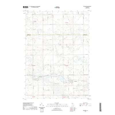
2019 Map of Vestaburg
USGS Topo · Published 2019About this map
Vestaburg and the neighboring settlement of Cedar Lake anchor this central Michigan landscape at the border of Isabella and Montcalm counties. The area is defined by a dense concentration of glacial kettle lakes and wetlands, including Rock Lake, Bass Lake, and Marl Lake, which dictate the irregular patterns of the local road network. The Fred Meijer Heartland Trail follows a clear east-west corridor through both primary settlements, tracing the path of a former rail line that once connected these rural communities. Genealogists will find the locations of the Cedar Lake Cem and Richland Cem clearly marked. To the north, the terrain becomes more fluid as the Pine River and the N Br Pine River transition through marshy lowlands near Bullhead Lake, illustrating the complex drainage of the Pine River watershed.
Find a feature on this map
79 named features on this map. Tap any name to fly to it.
Don’t see what you’re looking for? This feature index may not catch every label — zoom into the map to look around manually.
Map Details
Editions of this 2019 Vestaburg Map
This is the sole edition of this map. No revisions or reprints were ever made.
Other maps of this area

1916 · Mount Pleasant
USGS Topo · 1:62,500

1919 · Mount Pleasant
USGS Topo · 1:62,500

1943 · Mount Pleasant
USGS Topo · 1:62,500

1954 · Midland
USGS Topo · 1:250,000

1958 · Midland
USGS Topo · 1:250,000

1959 · Midland
USGS Topo · 1:250,000

1964 · Edmore
USGS Topo · 1:24,000

1964 · Blanchard
USGS Topo · 1:24,000

1964 · Stanton
USGS Topo · 1:24,000

1965 · Vestaburg
USGS Topo · 1:24,000