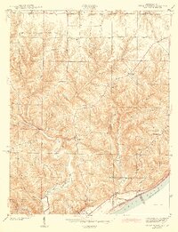
1943 Map of Vevay North
USGS Topo · Published 1943About this map
Vevay anchors the southern edge of this Switzerland County landscape along the Ohio River, where the town sits across from the Kentucky border. Surveyed by G. F. Westinghouse just before the war, the terrain is defined by a dense network of ridges and runs that dictated the settlement patterns of rural Indiana. Roads follow the high ground of Popcorn Ridge and Parks Ridge, connecting small community centers such as Mt Sterling and Allensville.
Find a feature on this map
32 named features on this map. Tap any name to fly to it.
Don’t see what you’re looking for? This feature index may not catch every label — zoom into the map to look around manually.
Map Details
Editions of this 1943 Vevay North Map
2 editions found
Other maps of this area

1943 · Florence
USGS Topo · 1:24,000

1943 · Aberdeen
USGS Topo · 1:24,000

1943 · Vevay North
USGS Topo · 1:24,000

1943 · Brooksburg
USGS Topo · 1:24,000

1943 · Vevay South
USGS Topo · 1:24,000

1951 · Florence
USGS Topo · 1:24,000

1951 · Sanders
USGS Topo · 1:24,000

1952 · Vevay South
USGS Topo · 1:24,000

1953 · Carrollton
USGS Topo · 1:24,000

1953 · Aberdeen
USGS Topo · 1:24,000