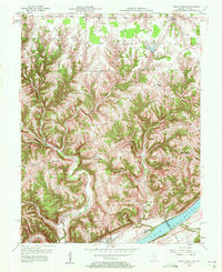
1957 Map of Vevay North
USGS Topo · Published 1958About this map
The Ohio River flows along the southern edge of this Switzerland County landscape, defining the boundary between Indiana and Kentucky. The town of Vevay serves as the focal point of the riverfront, situated across from Vevay Island and the navigable waters of the main channel. Inland, the terrain is characterized by a dense network of ridges such as Smith Ridge and Parks Ridge, which separate deep creek valleys including Indian Creek and Plum Creek. This 1950s survey captures a transition from river-centered commerce to upland farming communities like Mt Sterling and Fairview. Small rural gathering points are documented through the presence of the Plum Creek Ch and the Fredonia Ch, alongside the historically noted Jacksonville (Site), providing essential coordinates for researchers tracing family roots and mid-century land use in the Ohio River Valley.
Find a feature on this map
32 named features on this map. Tap any name to fly to it.
Don’t see what you’re looking for? This feature index may not catch every label — zoom into the map to look around manually.
Map Details
Editions of this 1957 Vevay North Map
2 editions found
Other maps of this area

1943 · Florence
USGS Topo · 1:24,000

1943 · Aberdeen
USGS Topo · 1:24,000

1943 · Vevay North
USGS Topo · 1:24,000

1943 · Brooksburg
USGS Topo · 1:24,000

1943 · Vevay South
USGS Topo · 1:24,000

1951 · Florence
USGS Topo · 1:24,000

1951 · Sanders
USGS Topo · 1:24,000

1952 · Vevay South
USGS Topo · 1:24,000

1953 · Carrollton
USGS Topo · 1:24,000

1953 · Aberdeen
USGS Topo · 1:24,000