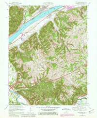
1967 Map of Vevay South
USGS Topo · Published 1981About this map
The Ohio River divides this landscape between Switzerland County, Indiana, and Carroll County, Kentucky, anchored by the riverfront towns of Vevay and Ghent. This 1967 survey (photorevised in 1980) details a transition from the river valley's industrial and municipal sites, such as the Sewage Disposal plant and Drive-in Theater near Vevay, to the upland ridges and creek bottoms of Kentucky. The southern portion of the map traces the path of the Louisville and Nashville railroad as it follows the course of Eagle Creek through Eagle Station.
Find a feature on this map
41 named features on this map. Tap any name to fly to it.
Don’t see what you’re looking for? This feature index may not catch every label — zoom into the map to look around manually.
Map Details
Editions of this 1967 Vevay South Map
3 editions found
Other maps of this area

1943 · Florence
USGS Topo · 1:24,000

1943 · Vevay North
USGS Topo · 1:24,000

1943 · Brooksburg
USGS Topo · 1:24,000

1943 · Vevay South
USGS Topo · 1:24,000

1950 · New Liberty
USGS Topo · 1:24,000

1951 · Florence
USGS Topo · 1:24,000

1951 · Sanders
USGS Topo · 1:24,000

1952 · Vevay South
USGS Topo · 1:24,000

1952 · Worthville
USGS Topo · 1:24,000

1952 · Campbellsburg
USGS Topo · 1:24,000