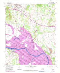
1967 Map of Vian
USGS Topo · Published 1983About this map
The Arkansas River corridor dominates this landscape, significantly reshaped by the waters of the Robert S. Kerr Reservoir. Along the northern edge, the community of Vian serves as a local hub, situated where the Missouri Pacific railroad and the Muskogee Turnpike intersect. The terrain transitions from the developed grid of Vian toward the sprawling wetlands of the Sequoyah National Wildlife Refuge, which protects a complex of inlets like Sally Jones Lake. This 1982 photorevision captures the impact of major water management and transportation infrastructure on eastern Oklahoma. To the south, across the county line in Liberty township, the settlement of Tamaha sits near the riverbanks, accompanied by its local Tamaha Cem and a nearby Strip Mine, indicating the varied economic life of the region from conservation and recreation to resource extraction.
Find a feature on this map
30 named features on this map. Tap any name to fly to it.
Don’t see what you’re looking for? This feature index may not catch every label — zoom into the map to look around manually.
Map Details
Editions of this 1967 Vian Map
4 editions found
Other maps of this area

1898 · Tahlequah
USGS Topo · 1:125,000

1900 · Sansbois
USGS Topo · 1:125,000

1900 · Sallisaw
USGS Topo · 1:125,000

1901 · Muscogee
USGS Topo · 1:125,000

1901 · Tahlequah
USGS Topo · 1:125,000

1905 · Muscogee
USGS Topo · 1:125,000

1905 · Tahlequah
USGS Topo · 1:125,000

1909 · Sans Bois
USGS Topo · 1:125,000

1911 · Sallisaw
USGS Topo · 1:125,000

1911 · Sansbois
USGS Topo · 1:125,000