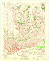
1970 Map of Vici SW
USGS Topo · Published 1972About this map
The Canadian River forms the southern boundary of this landscape, where the flat upland plains break into a complex network of eroded drainages and canyons. Ranching activity in the early 1970s is centered around the Cree Ranch and a nearby Landing Strip, illustrating the reliance on small-scale aviation for managing large parcels of land in rural Oklahoma. The northern sections of the map are defined by the Parkman terrain, while the central and southern reaches are dissected by numerous seasonal waterways including Turkey Creek, Spring Canyon, and South Turkey Creek. This era of the landscape is marked by isolated rural development, with the Stone Cem serving as a primary point of interest for genealogists tracing early families in the borderlands of Ellis, Dewey, and Roger Mills counties.
Find a feature on this map
20 named features on this map. Tap any name to fly to it.
Don’t see what you’re looking for? This feature index may not catch every label — zoom into the map to look around manually.
Map Details
Editions of this 1970 Vici SW Map
This is the sole edition of this map. No revisions or reprints were ever made.
Other maps of this area

1955 · Clinton
USGS Topo · 1:250,000

1955 · Woodward
USGS Topo · 1:250,000

1957 · Clinton
USGS Topo · 1:250,000

1958 · Woodward
USGS Topo · 1:250,000

1961 · Leedey
USGS Topo · 1:62,500

1965 · Roll NE
USGS Topo · 1:24,000

1969 · Vici NW
USGS Topo · 1:24,000

1969 · Camargo
USGS Topo · 1:24,000

1969 · Vici
USGS Topo · 1:24,000

1970 · Harmon
USGS Topo · 1:24,000