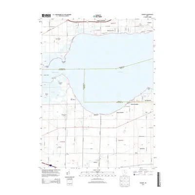
2013 Map of Vickery
USGS Topo · Published 2013About this map
Sandusky Bay dominates the central landscape of this coastal Ohio region, where the marshy transition between Lake Erie and the mainland defines local life and industry. Along the southern shore, small residential and maritime pockets like Whites Landing, Bayshore, and Sunset Harbor sit adjacent to the extensive Pickerel Creek Wildlife Area, indicating a coastline managed for both recreation and conservation. The interior reveals a agricultural and small-town character, anchored by the community of Vickery and punctuated by family-named landmarks such as Meggitt Farms and McCreary Farm Cem. North of the bay, the geography shifts toward industrial and aviation interests, featuring the town of Gypsum and private flight facilities like Boggy Bottoms Airport. The map also captures numerous islands and points with evocative names, including Graveyard Island, Canvasback Point, and Winous Point, reflecting the area's deep-rooted waterfowl hunting and fishing traditions.
Find a feature on this map
54 named features on this map. Tap any name to fly to it.
Don’t see what you’re looking for? This feature index may not catch every label — zoom into the map to look around manually.
Map Details
Editions of this 2013 Vickery Map
This is the sole edition of this map. No revisions or reprints were ever made.
Other maps of this area

1900 · Oak Harbor
USGS Topo · 1:62,500

1901 · Put-In-Bay
USGS Topo · 1:62,500

1901 · Bellevue
USGS Topo · 1:62,500

1901 · Fremont
USGS Topo · 1:62,500

1903 · Bellevue
USGS Topo · 1:62,500

1903 · Fremont
USGS Topo · 1:62,500

1903 · Put In Bay
USGS Topo · 1:62,500

1952 · Lacarne
USGS Topo · 1:24,000

1952 · Oak Harbor
USGS Topo · 1:62,500

1956 · Toledo
USGS Topo · 1:250,000