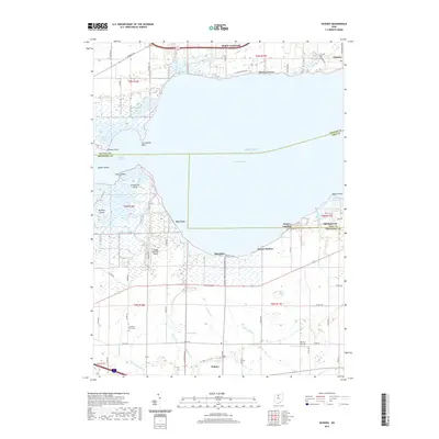
2019 Map of Vickery
USGS Topo · Published 2019About this map
Sandusky Bay and Muddy Creek Bay dominate this 2019 survey, where the freshwater marshes of the Lake Erie shoreline meet the agricultural lowlands of Ottawa, Sandusky, and Erie counties. The landscape is defined by its complex hydrology, featuring the Winous Point Marsh and the extensive Pickeral Creek Wildlife Management Area, which protect vital wetland habitats. Small lakeside communities such as Bay View, Whites Landing, and Sunset Harbor line the southern shore, while the city of Port Clinton anchors the northern edge near the industrial enclave of Gypsum. Inland, the terrain is remarkably flat, drained by an intricate network of waterways including Pickerel Creek, Scherz Ditch, and Little Raccoon Cr. For genealogists and local historians, the map preserves the location of the McCreary Farm Cem and small rural hubs like Vickery, alongside aviation landmarks such as Boggy Bottoms Airport and Warner Airstrip.
Find a feature on this map
68 named features on this map. Tap any name to fly to it.
Don’t see what you’re looking for? This feature index may not catch every label — zoom into the map to look around manually.
Map Details
Editions of this 2019 Vickery Map
This is the sole edition of this map. No revisions or reprints were ever made.
Other maps of this area

1900 · Oak Harbor
USGS Topo · 1:62,500

1901 · Put-In-Bay
USGS Topo · 1:62,500

1901 · Bellevue
USGS Topo · 1:62,500

1901 · Fremont
USGS Topo · 1:62,500

1903 · Bellevue
USGS Topo · 1:62,500

1903 · Fremont
USGS Topo · 1:62,500

1903 · Put In Bay
USGS Topo · 1:62,500

1952 · Lacarne
USGS Topo · 1:24,000

1952 · Oak Harbor
USGS Topo · 1:62,500

1956 · Toledo
USGS Topo · 1:250,000