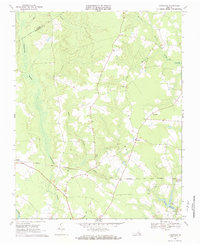
1969 Map of Vicksville
USGS Topo · Published 1984About this map
Assamoosick Swamp dominates the western edge of this Southampton County landscape, creating a broad hydrologic boundary that separates Sebrell from the central uplands. The Norfolk and Western railroad cuts a straight horizontal line across the southern half of the map, serving as a primary transportation artery for the small crossroads communities of the late 1960s. Rural life here is anchored by local congregations at St Lukes Ch, Zion Ch, and St Pauls Ch, while the settlement at Vicksville features a prominent Lookout Tower. The topography is characterized by a network of drainage systems like Indian Run and Indigo Branch that feed into the larger swamp complexes and the NottowAY R in the south. These water features, alongside the Darden Millpond, illustrate the historical reliance on local milling and the natural drainage patterns that dictated the placement of early roads and homesteads.
Find a feature on this map
37 named features on this map. Tap any name to fly to it.
Don’t see what you’re looking for? This feature index may not catch every label — zoom into the map to look around manually.
Map Details
Editions of this 1969 Vicksville Map
Other maps of this area

1919 · Homeville
USGS Topo · 1:48,000

1919 · Boykins
USGS Topo · 1:48,000

1920 · Holland
USGS Topo · 1:62,500

1920 · Ivor
USGS Topo · 1:62,500

1920 · Homeville
USGS Topo · 1:62,500

1920 · Boykins
USGS Topo · 1:62,500

1943 · Holland
USGS Topo · 1:62,500

1943 · Sebrell
USGS Topo · 1:31,680

1943 · Manry
USGS Topo · 1:31,680

1943 · Littleton
USGS Topo · 1:31,680