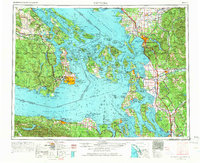
1957 Map of Victoria
USGS Topo · Published 1966About this map
Victoria anchors this mid-century survey of the Salish Sea, serving as a hub where the Esquimalt and Nanaimo Railway meets the southern end of the Saanich Peninsula. The map documents the intricate coastline of the San Juan Islands and the burgeoning industrial corridor of the Puget Sound's northern reaches. From the major terminals at Everett and Bellingham to the military installations on Whidbey Island, the landscape reflects a post-war era of significant maritime and aeronautical activity, evidenced by NAS Whidbey Island (Ault Field).
Find a feature on this map
334 named features on this map. Tap any name to fly to it.
Don’t see what you’re looking for? This feature index may not catch every label — zoom into the map to look around manually.
Map Details
Editions of this 1957 Victoria Map
4 editions found

Other maps of this area

1895 · Snohomish
USGS Topo · 1:125,000

1897 · Seattle
USGS Topo · 1:125,000

1899 · Stillaguamish
USGS Topo · 1:125,000

1901 · Stilaguamish
USGS Topo · 1:125,000

1906 · Sumas
USGS Topo · 1:62,500

1907 · Blaine
USGS Topo · 1:62,500

1908 · Sumas
USGS Topo · 1:62,500

1909 · Mt Baker
USGS Topo · 1:192,000

1911 · Mount Vernon
USGS Topo · 1:125,000

1915 · Mt. Baker
USGS Topo · 1:250,000