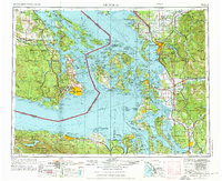
1957 Map of Victoria
USGS Topo · Published 1976About this map
The Victoria regional corridor serves as a maritime and terrestrial crossroads where the Strait of Juan de Fuca meets the Strait of Georgia. This mid-century survey documents the complex archipelago of the San Juan Islands and the coastal development of Whatcom and Skagit counties. Industrial markers of the era are prominent, including the Bellingham Coal Mine and the Anacortes Oil Refinery, while the Peace Arch at Blaine denotes the international boundary with British Columbia. On the Olympic Peninsula, Port Angeles Harbor and the northern reaches of Olympic National Park provide a backdrop to the maritime traffic lanes indicated by various ferry routes. The map traces the extensive rail networks of the Great Northern Railway and the Milwaukee Road, which linked the timber and agricultural resources of the Cultus Mountains and Mount Baker to the Puget Sound ports.
Find a feature on this map
249 named features on this map. Tap any name to fly to it.
Don’t see what you’re looking for? This feature index may not catch every label — zoom into the map to look around manually.
Map Details
Editions of this 1957 Victoria Map
4 editions found

Other maps of this area

1895 · Snohomish
USGS Topo · 1:125,000

1897 · Seattle
USGS Topo · 1:125,000

1899 · Stillaguamish
USGS Topo · 1:125,000

1901 · Stilaguamish
USGS Topo · 1:125,000

1906 · Sumas
USGS Topo · 1:62,500

1907 · Blaine
USGS Topo · 1:62,500

1908 · Sumas
USGS Topo · 1:62,500

1909 · Mt Baker
USGS Topo · 1:192,000

1911 · Mount Vernon
USGS Topo · 1:125,000

1915 · Mt. Baker
USGS Topo · 1:250,000