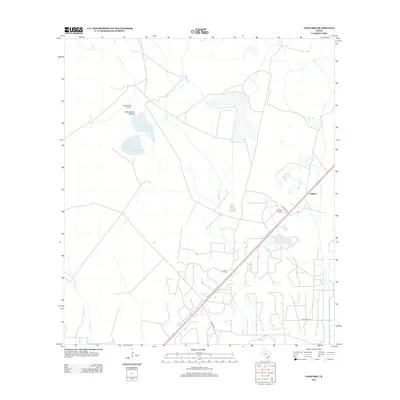
2013 Map of Vidaurri
USGS Topo · Published 2013About this map
Vidaurri sits as a primary settlement node in this coastal Texas landscape, where the petroleum industry and cattle ranching intersect. The extraction history of Refugio County is evident in the presence of the West Vidaurri Oil Field and the Greta Oil Field, which share the terrain with sprawling landholdings like Welder Ranch. Surface water defines much of the eastern and southern drainage, with Copano Cr and Melon Cr winding through the coastal plains. Unusual features like N Saint Nicholas Lake and S Saint Nicholas Lake offer distinct landmarks near Cottonwood Hollow, while the southern reaches include the large expanse of Lake Pasture. This survey captures the rural infrastructure of the early 21st century, from the primary corridor of Vidaurri Rd to the network of local access points like Quintana Rd that serve the area's oil and agricultural interests.
Find a feature on this map
13 named features on this map. Tap any name to fly to it.
Don’t see what you’re looking for? This feature index may not catch every label — zoom into the map to look around manually.
Map Details
Editions of this 2013 Vidaurri Map
This is the sole edition of this map. No revisions or reprints were ever made.
Other maps of this area

1953 · Beeville
USGS Topo · 1:250,000

1954 · Vidaurri
USGS Topo · 1:62,500

1954 · Refugio
USGS Topo · 1:62,500

1956 · Beeville
USGS Topo · 1:250,000

1960 · Beeville
USGS Topo · 1:250,000

1962 · Live Oak Lake
USGS Topo · 1:24,000

1962 · Lott Lake
USGS Topo · 1:24,000

1962 · McFaddin
USGS Topo · 1:24,000

1978 · Ryanville
USGS Topo · 1:24,000

1978 · Vidaurri
USGS Topo · 1:24,000