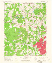
1966 Map of Vienna
USGS Topo · Published 1967About this map
The master-planned community of Reston stands in its early stages of development on this mid-1960s survey, centered around the modern Lake Anne Village and Lake Anne. This era marks a significant transition for northern Virginia as the rural character of older settlements like Dranesville and Hunter gives way to suburban expansion. The infrastructure of the period is defined by the Washington and Old Dominion Railroad, which passes through Sunset Hills, and the newly constructed Dulles Airport Road slicing through the landscape. Along Difficult Run and its tributaries, the terrain remains wooded, preserving sites like Browns Mill and Browns Chapel Cem. The growth of Vienna is evident in the dense residential blocks of Vienna Woods and the establishment of Madison High Sch, while the northern edge of the map reaches the Potomac River at the falls, featuring Olmsted Island within Great Falls Park.
Find a feature on this map
97 named features on this map. Tap any name to fly to it.
Don’t see what you’re looking for? This feature index may not catch every label — zoom into the map to look around manually.
Map Details
Editions of this 1966 Vienna Map
2 editions found
Other maps of this area

1890 · Mt. Vernon
USGS Topo · 1:125,000

1891 · Mt. Vernon
USGS Topo · 1:125,000

1893 · Frederick
USGS Topo · 1:125,000

1894 · Frederick
USGS Topo · 1:125,000

1894 · Mt. Vernon
USGS Topo · 1:125,000

1897 · Mt. Vernon
USGS Topo · 1:125,000

1900 · Washington
USGS Topo · 1:62,500

1908 · Rockville
USGS Topo · 1:62,500

1908 · Seneca
USGS Topo · 1:62,500

1915 · Fairfax
USGS Topo · 1:62,500